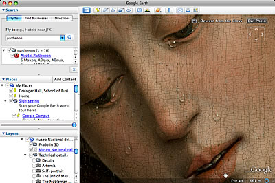
IMAGE: An extreme close-up of Rogier van der Weyden’s painting,
”Descent from the Cross” (ca. 1435), as seen through Google Earth.
Google unveiled two new layers for their Google Earth system, which allows anyone with a reasonably good computer and broadband connection to fly around and explore the globe. The core of Google Earth is its three-dimensional imaging database, that wraps satellite images around a representation of the earth. But the architecture of the software allows lots of interesting things to happen on the surface (and below the surface) of those images.
Take for example the new bundle of layers adding depth (literally) and texture to the water portions of our world, the oceans (described here in some detail). If you switch on this layer, you’ll encounter photos, videos, text, and even three-dimensional worlds to explore below the surface and around the shores.
Or, consider the Google Earth partnership with the Prado museum in Madrid (thanks Katie, for the link), that exploits the program’s extraordinary imaging engine to allow extremely close inspection of master works. You can also explore a three-dimensional rendering of the museum, or view photos taken by ordinary folks who chose to post them to the web.
The two new layers provide further evidence that Google is not a software company, nor is it a search engine. Rather, it’s an architectural firm that builds infrastructure, interfaces, and extraordinary spaces for a full range of human insights and inventions to come together.

