In some chairs in some room in New York City in 1980s, Kyong Park and I discussed a guerilla project to block out all the street signs in a section of Manhattan. In a few hours could we paint over every name: 33rd, 32nd, 31st…..? Would a traffic jam ensue in the morning? Would the government of New York respond like an emergency or just let it be until the streets department replaced them in a few weeks.
What is the relationship between phenomena geography and the signed geography? In general, the new or infrequent visitor exhibits massive frustration at missing street names and hard to find street numbers. Especially from the road, physical stuff – trees, light poles, decorative architecture – blocks the view to the naming and numbering. With clear and consistent placement, the mathematical geography dominants and comforts the visitor.

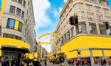
Yesterday through the blog of Cennydd Bowles, I learned of the 2005 public project of art and civic space by Christoph Steinbrener & Rainer Dempf. “Delete! Delettering the Public Space” covered every sign with yellow fabric on a narrow shopping street in old Vienna. The two-week installation had nothing to do with the mathematical navigation of space and everything to do with flattening of space with graphic yellow.
I have been in urban places with extremely reduced advertising signs: Fez, Morocco and Havana, Cuba. In places such as China and Japan, the signs are visual, but without meaning to the western reader. Reading in the street ceases and staring begins. Your eyes need to find new places to land. Volume and activity of the space are continuously felt. Or in reverse, the signed space breaks the continuity and the mind leaps to reading and even to vocalizing. We are trapped in our priority toward words.
Steinbrener and Dempf removed the words, not the signs, from one block. After the game of guessing the covered names is boring, the eyes bounce from yellow to yellow. The “layer of the signs” over the architecture becomes palpable. The smooty blending of plastic and stone ends.
Fresh yellow, especially on a cloud day with perfect digital camera lighting, removes the perspective. A place in the city is flattened with non-spatial graphics. The yellow at the back is not farther, just smaller. Our digital eye emerges in real space.
Has the digital eye replaced the perspectival eye? How many centuries before our painters grasp perspective and how many more until designers cut pure perspective shaped the trees of French gardens and placed the monuments at the end of boulevards? Where is the digital sending our real space?
Back to the street signs. Street signs require a sense of mathematics, a mental overlay in order to travel in the right direction. Signs may repress the 3-D city (so significant for the stable resident), but the geography is at least 2-D. With the dashboard mounted GPS, the world is one dimensional – just follow the line and turn left or right as directed. In one dimension, even the most minor cross-references and nearby connections are ignored. Geography is irrelevant. Where is the digital sending relationship with space?
Public Art, Public Space
